


Rich Intercounty Drain
Continued ...
In all, six grade control structures were installed along the two mile project area. Ten new rock chute side inlets were installed, five drainage inlets were stabilized, and over eighteen acres of buffer strips were re-established. It is proposed to extend this project to other reaches of this drain to institutionalize the practices along the entire extent of the facility.
The effort expended by the Lapeer County Drain Commissioner on behalf of the Rich Intercounty Board in informing riparian landowners about the importance of management of the riparian zone was a valuable contribution to understanding the importance of the measures in maintaining the integrity of the facility.
The Rich Intercounty Drain straddles the county line between Lapeer County and Tuscola County just east of the Fostoria “notch”. The drain is predominantly agricultural with the Village of Mayville lying at its upper extent in Tuscola County. The drain courses downstream from Mayville at grades over 1% down to Lapeer County. Contour grades in the riparian zone of the drain exceed 4% in many areas. The drain is an important outlet for storm drainage for the Village and provides an outlet for sewage treatment outflows as well. The presence of treated sewage discharge makes management and reduction of sediment in the drain very important as sediment provides a pathway for other nutrients in the drain discharge. Downstream of Tuscola County, the grades flatten but flow velocities at flood stage average approximately 7 feet per second. Soils vary from clay loam to fine sandy loam creating a condition conducive to erosion of bed and banks.
The last petitioned project in 1982 provided rock armor protection and control structures along the length of the drain to mitigate inflows from the fields and roads. Land use practices during the interval from 1982 to 1996 placed agricultural tillage and crops at the edge of the drain and right up to the inlet of the erosion control structures. In May, 1996 a record flood damaged the drain severely and inspired a repair project that included grade controls, bank reshaping, and repair of damaged inlets. During that time period the drainage district invested in easements along the drain to provide buffer strips of grass vegetation out to 75 feet or more on each side of the drain. These strips are intended to protect the banks from failure that was seen in 1996.
In early April 2013, the Lapeer County Drain Commissioner received a call from a landowner that was experiencing erosion problems. When he arrived at the site, indications were clear that the culprit was Roundup and over bank farming practices. The soil conditions simply could not withstand bare banks. Steel pipe inlets had been degraded by the sediment laden inflows. Runoff directed by plow furrows directed flows overbank in many areas causing deep rills and gullies.
The Board retained Stacy Hissong of Fahey Schultz Burzych Rhodes PLC to review the easements and provide a determination on the strength of the Board’s decision in enforcing the buffers. A positive determination from Stacy set the planned project in motion.
Within a couple of weeks, the project area was identified, communication with the Intercounty Board continued and by April 17, 2013 a scope of work and recommendations on measures were made. A review of the drain easements at this time revealed that the riparian landowners along the drain had made the buffer strip agreements and that some of the farming along the drain was in violation of the agreements.
While notices were mailed informing the landowners of the violation and the Board’s intent to re-establish the buffer strips, bid documents and drawings were prepared to implement the Board’s decision. A number of management practices were implemented for the project including rock chutes, drop structures for erosion control, and grade control structures.


Excess sediment in the drain combined with soil types and steep drain grades created instability and damage to the channel.
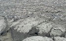


Runoff discharging over bare banks created severe erosion and damage to the channel.
Rock chutes were constructed to route surface runoff into the drain at protected locations.
Farm Swales and plow furrows directing runoff to bare banks advanced bank damage along the affected reaches.
Rich Township in Lapeer County provided added support to the project allowing the full project cost to be allocated to one year as a maintenance assessment. The project computation of cost of $78,000 exceeded the normal $5,000 per mile allowance without a resolution to exceed.
The buffer strips are very simple in design in this case and provide isolation of the drain from direct surface water discharge of nutrients. The stabilization of the tile inlets provide protection of the channel from erosion damage. Similarly, the rock chutes and other inlet
management practices serve to protect the channel from damage from runoff.


Buffer strips were graded and contoured to capture and direct runoff. A seedbed was prepared to accept the grass seed mix.

Ultimately, the practice of maintaining a vegetative buffer strip requires an understanding and acceptance by land owners and drain commissioners to become ubiquitous and common practice. While buffer strips are common in the area, they remain in place only as a subject of subsidy. Once the subsidies are gone or perceived as inadequate, landowners don’t perceive other value to inspire the continuation of the practice. The decisions and actions taken by the Rich Intercounty Drain Board are a positive example and first step toward an understanding of the intrinsic value of Riparian Zone Management.
Re-designed upland drain-age utilized runoff control points engineered to reduce sediment.

Grade control and side inlet stabilization was installed along the project area.
Overbank farming and killing of bank vegetation was commonplace in some reaches.
Newly managed riparian zone with vegetated strips growing in